Changelog 3.14 Pi - A work created by Pigrecoinfinito
📧 Info!
Thanks to the precious help of Andrea Borruso
Pigrecoinfinito has collected on this page some views of the changelog 3.14 Pi (π) 😊.
The following changelogs are the result of this filter:
is:pr is:closed label:feature merged:2020-02-22T00:00:00Z..2020-05-15T12:00:00Z
- Release date freeze : 15 May,2020
- Release date packaging: 19 June, 2020
- Release date: 22 June, 2020
- QGIS: https://qgis.org/it/site/
- Repository: https://github.com/qgis/QGIS
- Tweet QGIS 3.14 Pi: https://twitter.com/totofiandaca/status/1244960239193120771

- Chair : Marco Bernasocchi
-
Vice-Chair : Alessandro Pasotti
-
honorary PSC members: Gary Sherman, Tim Sutton
- honorary QGIS members: Harrissou Sant-anna, Nyall Dawson
UPDATED 2020-05-15T12:00:00Z - 133 features
- Features
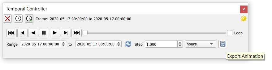
- Add ability to export animation frames
- Add additional temporal modes for vector layers
- use only specified dataset group
- New variables @animation_start_time and @animation_end_time
- scalar color settings depending on classification
- Add cumulative temporal range setting in temporal controller
- Expose temporal UI for map items
- allow adding attributes in the New Scratch Layer dialog (fix #24397)
- Respect HTML colors in labels
- add Selection toolbar to the QGIS main window
- Determine primary key from Oracle view
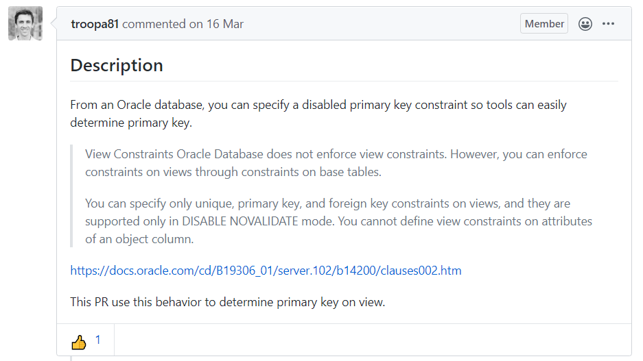
- New expression function make_interval
- Add expression variables for frame properties
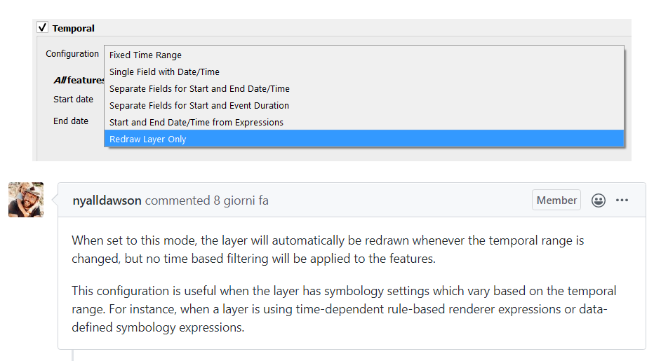
- Add a new Redraw Layer Only mode for temporal vector layers
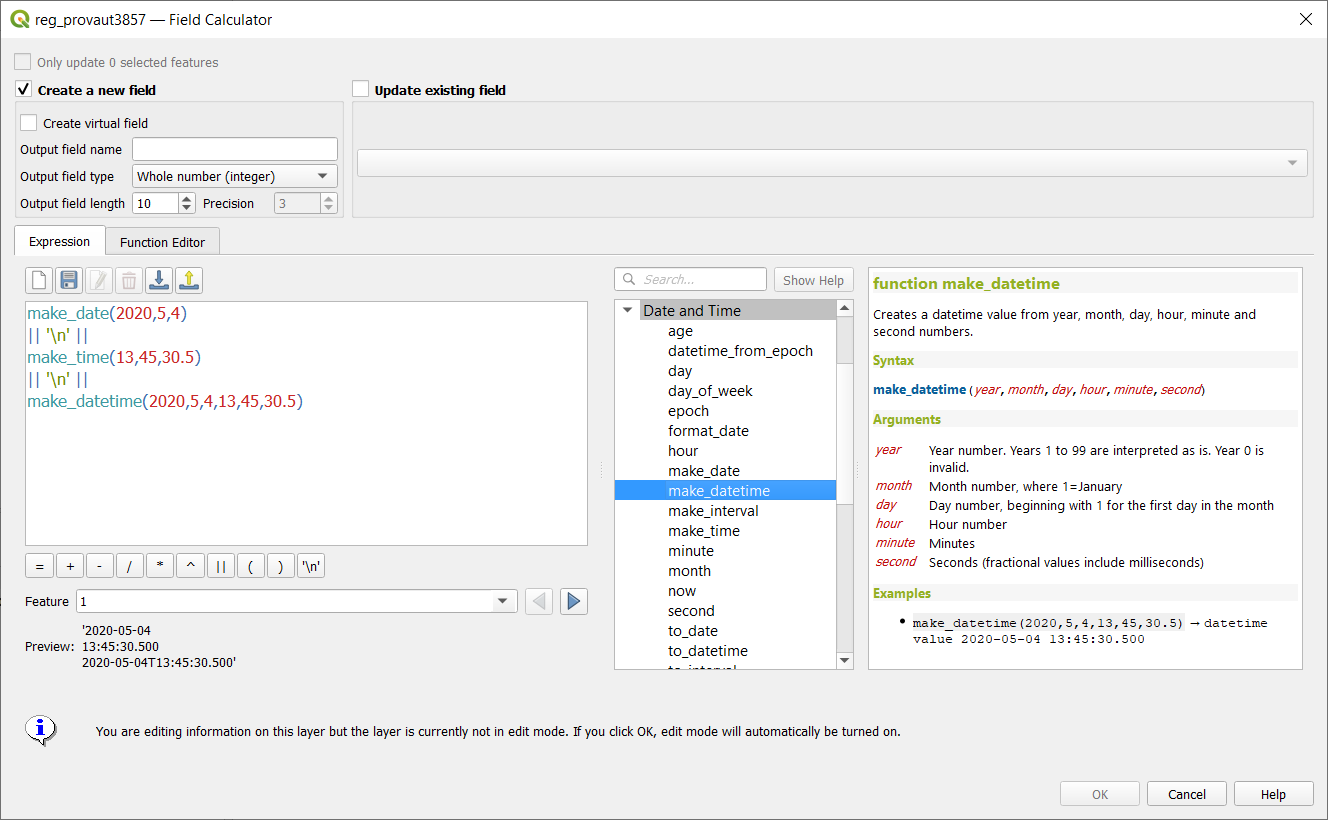
- Add make_date, make_time and make_datetime functions
- Add basic temporal handling support for vector layers
- allow sorting attribute table by field not listed in the table
- Allow customisation of division and subdivision symbols as distinct from scalebar tick horizontal symbol
- allow creating geometryless DBF tables from the New Shapefile dialog (fix #15654)
- Vector tile layer - part 8 (writer in Processing)
- allow to drag’n’drop layer across several QGIS instances
- enhance sorting capabilities in attribute table list/form view
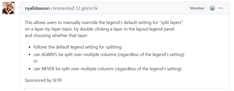
- Expose control over layer legend splitting behavior on a layer-by-layer basis
- allow editing of links in file widget
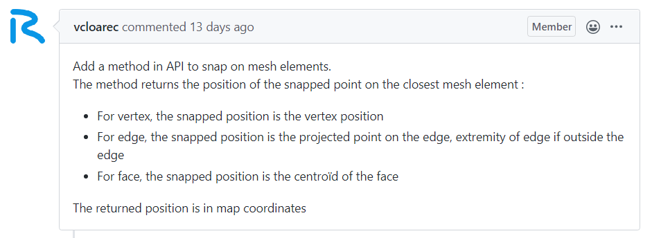
- Snap on mesh elements
- Allow filtering WM(T)S list in source dialog
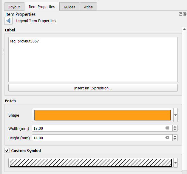
- Allow overriding the default symbol for a legend node
- Allow placing manual column breaks in legends
- Add subdivisions in ticksscalebar right segments
- Complete random raster algorithm collection #2
- Automatic placement of labels outside polygons
- Feature browser for preview in expression builder
- add expression close_line
- Allow overriding the legend patch size on a per-item basis
- Allow control over the horizontal spacing before legend group/subgroup/symbols
- Support for adding dock widgets as tabs
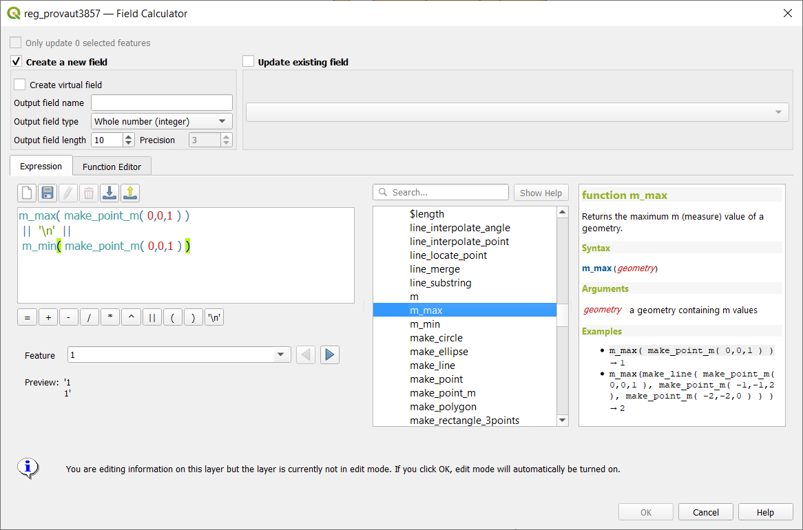
- Expressions for geometry Z and M minimum and maximum
- 1D mesh width/color varying
- Allow renaming of the current map theme
- Manage legend patch shapes through style manager
- ability to remove custom functions (fix #27513)
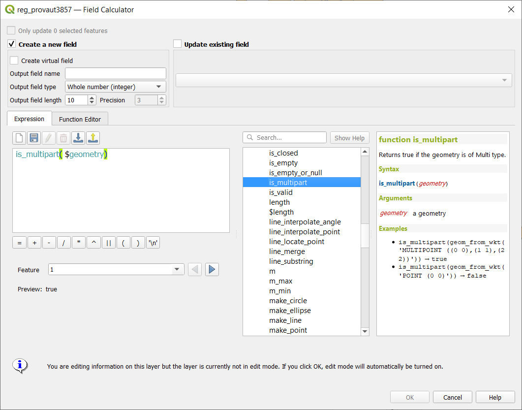
- add is_multipart expression for geometry
- Allow configuring legend patch shapes by double-clicking on legend items
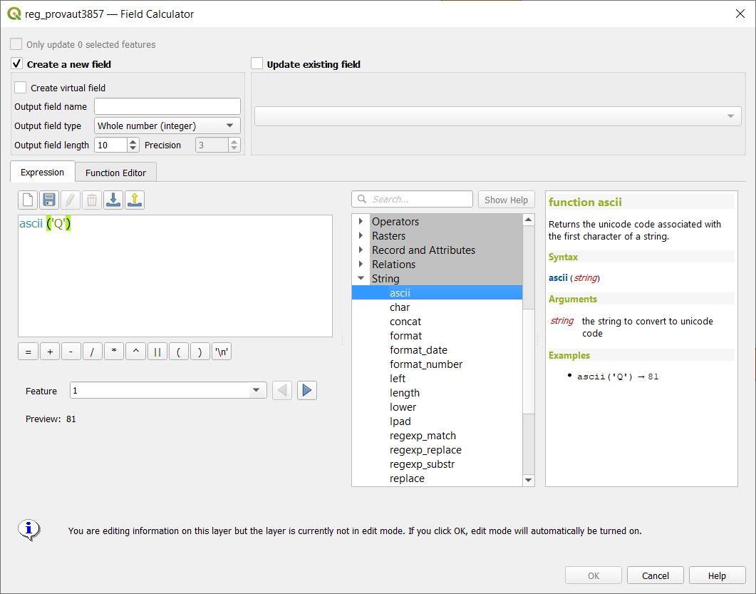
- ascii expression
- Support pasting pictures directly into layouts
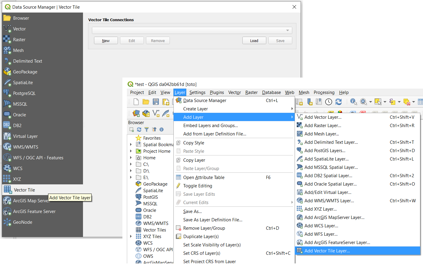
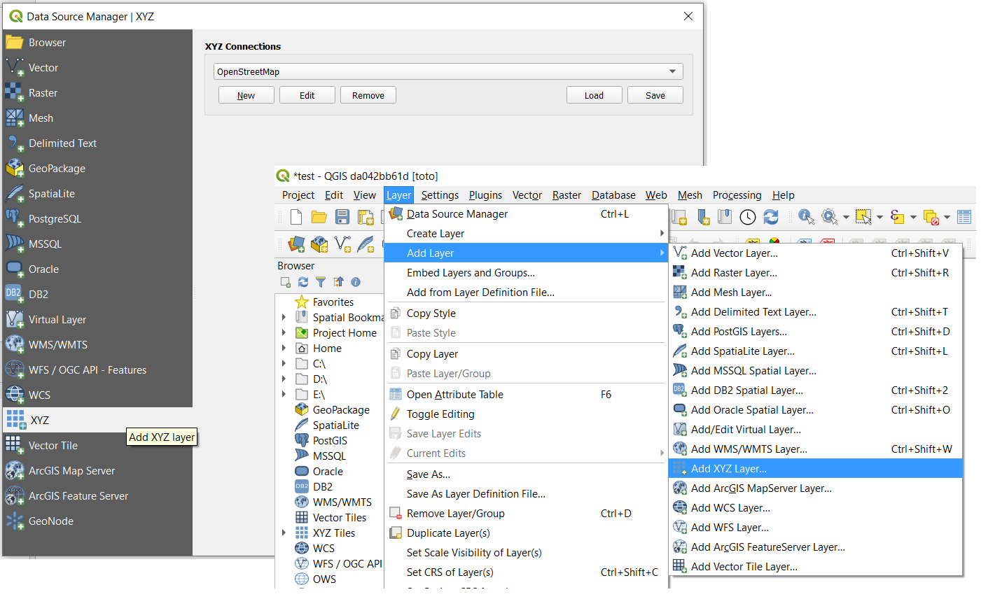
- Add vector tiles to Datasource manager dialog and Layers menu
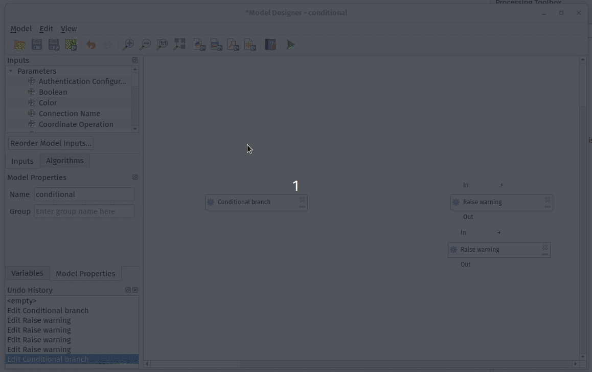
- New modeler algorithm for creating conditional branches
- import/export for ArcGIS Map and FeatureServer connections
- Allow reordering model inputs
- Add XYZ tiles to Datasource manager dialog and Layers menu
- Defer model validation
- Vector tile layer - part 5 (identify tool)
- Server add QGIS_SERVER_IGNORE_BAD_LAYERS config option
- Update to MDAL 0.5.91 Multi meshes in one file
- Add support for different raster data types in Create constant raster layer algorithm
- add native Round raster algorithm
- Add avoid intersection/overlap mode
- Forms: expression controlled aliases (labels)
- Vector tile layer - part 4 (labeling)
- Allow copying/cut/paste of model components
- Allow appending processing results to existing layers
- Allow plugins to register custom Project Open handlers
- Allow marker items to sync rotation with maps
- New item type for marker symbols
- Expression builder add layer_property
- Added move to bottom in layertreeview context menu
- Show a menu next to scale widget buttons, to allow setting the widget directly to a scale from a print layout map
- Postgres raster temporal API support
- Allow creation of group boxes in models
- Spatialite provider transactions
- Port output parameter wrappers to new API
- Add import content from clipboard for fixed table items
- Processing: show input and output values for children after running model through designer
- Add Save Log to File algorithm for models
- plug mesh layer to QGIS temporal framework
- Network logger - more functionality
- Port last remaining input parameters to new API
- Raster Layer Contour Renderer
- Add percentage size unit for Raster Image Marker and Raster fill layers symbology.
- Port Feature Source, Raster, Vector and Mesh Layer parameters to new API
- Server project settings, add ‘expanded’ attribute
- Inbuilt network logging tool
- Allowing saving outputs direct to more database formats (and other nice stuff)
- Vector tile layer - part 1
- Allow running algorithms directly on database (and other non-disk) sources without loading into projects first
- Port processing extent parameter to new api, many other improvements
- Interface and API for unified development/debugging tools
- Expose per-feature-source advanced options for processing inputs
- Resampling from vertex values to face values
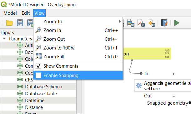
- Enable snapping to grid for models in designer
- Add numeric formatter fraction style
- Add stepped line and hollow scalebar styles
- Allow scalebar line style to be set using standard QGIS line symbols
- Add data-defined property to font family/style for font markers
- coloring mesh vector dataset with color ramp shader
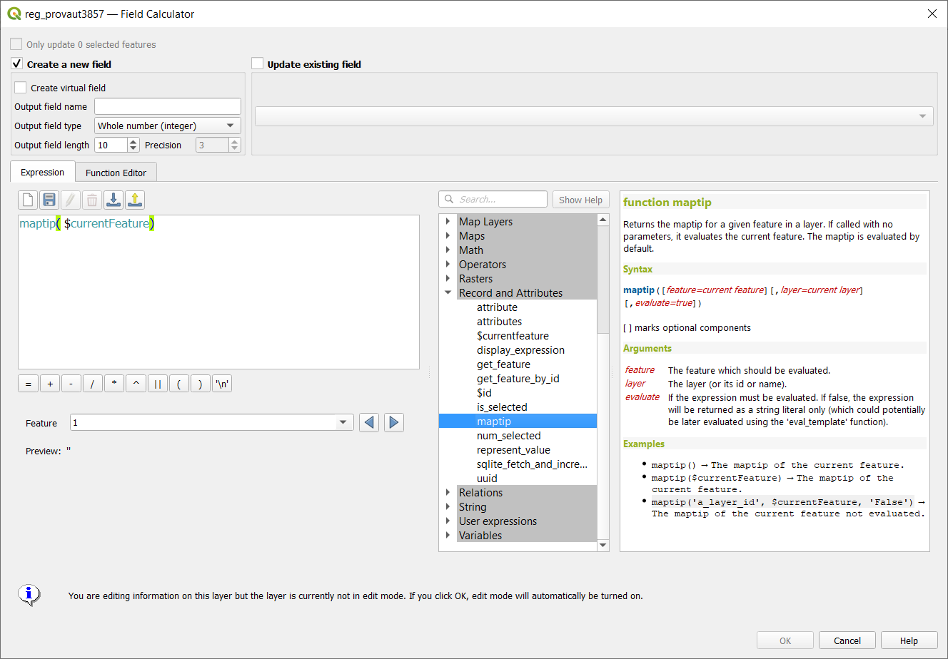
- add maptip, expression display and eval_template expressions
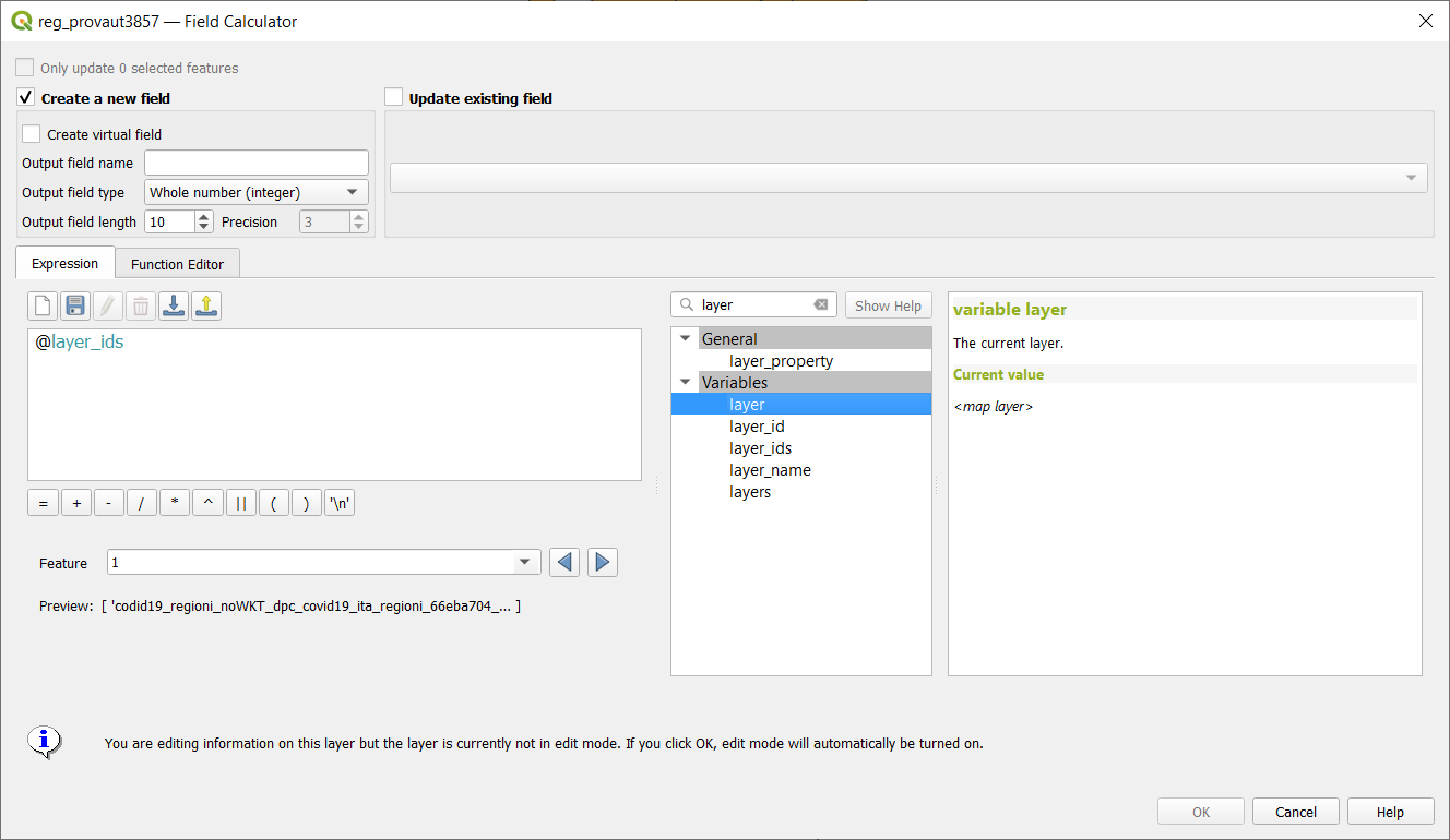
- Add @layers, @layer_ids project scope variables
- Add a font style setting for font markers
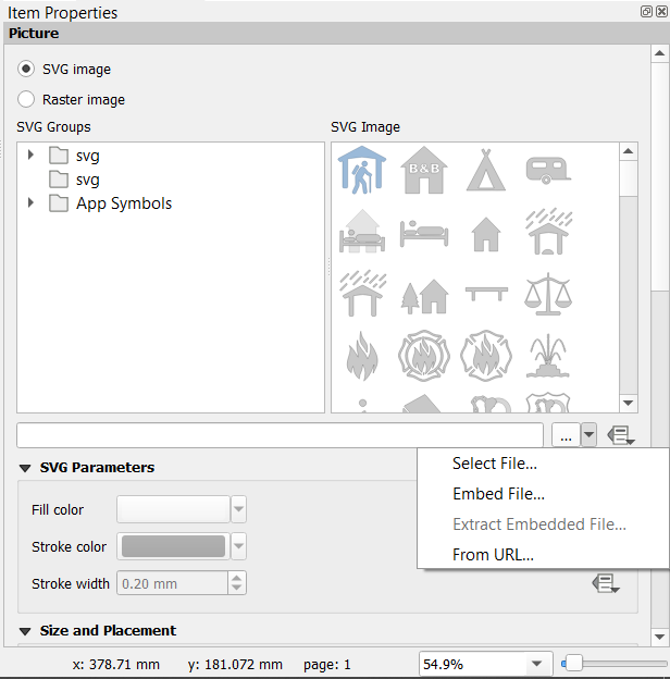
- Rework picture item UI and behavior
- Add filter by geometry type and filter by layer type algorithms to processing
- Add ability to edit, import and export user expressions
- Make Add Group button act as Group Selected if selected layers >= 2
- Optionally, also remove EMPTY geometries in RemoveNullGeometries algorithm
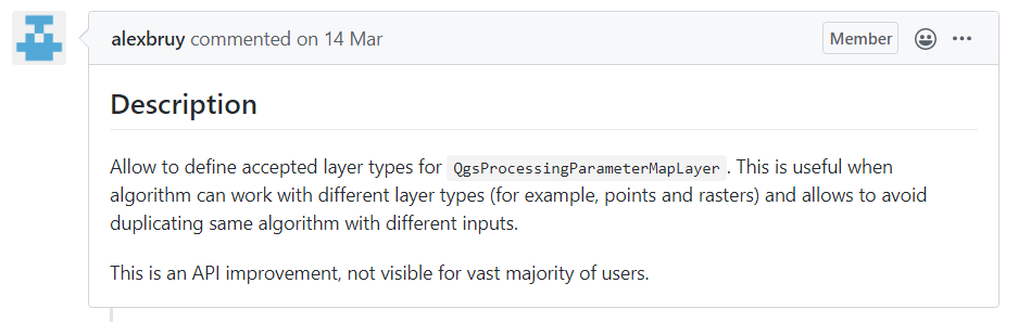
- Data type support for QgsProcessingParameterMapLayer
- Add processing parameter types for database schema and table name
- Add description to value relation widget
- Add multi-selection handling to model designer, interactive resizing
- Save style for mesh layer
- New database table name widget
- Add dedicated parameter type for database connections
- arrows for 3D mesh layer dataset rendering
- Add undo/redo support to model designer
- Add control over anchor point for callout on label
- PG expose foreign tables
- Add expression variables for current map temporal range
- Remember parameter values between model designer runs
- Plugin manager allow to install stable or experimental
- PG raster expose set filter to app
- Comments in Processing Models
- Mesh 1D Renderer
- Get current parent form values in child forms
- Relation wdgt: add checkbox to hide save child edits button
- Relation widget force suppress popup
- New standalone console tool for running processing algorithms
- New parameter type for Merged (or date, or time) values
- QGIS Project temporal settings
- Make CRS controlable by a variable
- Mesh simplification
- WMS-T layers temporal constrains support
- Temporal API
- New snapping modes: Centroid and middle of a segment (midpoint)
- Show ‘template layer’ constraints info in the Refactor fields algorithm’s UI
- Statistics
Features
Add ability to export animation frames
- Author: nyalldawson
- Milestone: 3.14.0
- PR: 36453
- Merged: 2020-05-15T06:10:54Z
- tags: Temporal
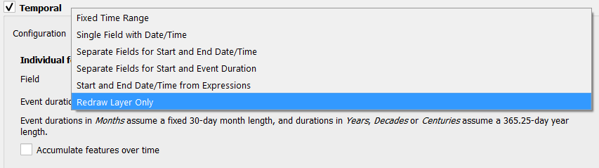
Add additional temporal modes for vector layers
- Author: nyalldawson
- Milestone: 3.14.0
- PR: 36367
- Merged: 2020-05-13T10:20:01Z
- tags: Temporal
use only specified dataset group

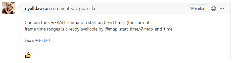
New variables @animation_start_time and @animation_end_time
- Author: nyalldawson
- Milestone: 3.14.0
- PR: 36324
- Merged: 2020-05-10T09:33:35Z
- tags: Expressions; Temporal
scalar color settings depending on classification

Add cumulative temporal range setting in temporal controller

Expose temporal UI for map items
- Author: nirvn
- Milestone: 3.14.0
- PR: 36304
- Merged: 2020-05-10T07:30:08Z
- tags: Print Layouts; Temporal

allow adding attributes in the New Scratch Layer dialog (fix #24397)

Respect HTML colors in labels
- Author: nyalldawson
- Milestone: 3.14.0
- PR: 36283
- Merged: 2020-05-12T11:16:57Z
- tags: -
- Sponsored by geoProRegio AG (www.geoproregio.ch)

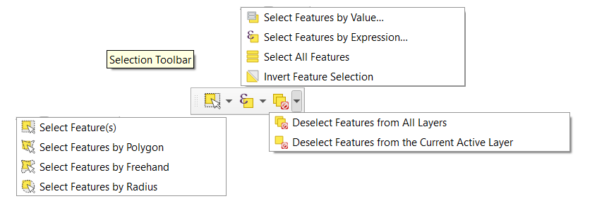
add Selection toolbar to the QGIS main window
Determine primary key from Oracle view
New expression function make_interval
- Author: nyalldawson
- Milestone: 3.14.0
- PR: 36303
- Merged: 2020-05-09T10:22:54Z
- tags: Expressions
Add expression variables for frame properties
- Author: nyalldawson
- Milestone: 3.14.0
- PR: 36300
- Merged: 2020-05-09T08:07:00Z
- tags: Temporal

Add a new Redraw Layer Only mode for temporal vector layers
- Author: nyalldawson
- Milestone: 3.14.0
- PR: 36299
- Merged: 2020-05-09T08:06:37Z
- tags: Temporal
Add make_date, make_time and make_datetime functions
- Author: nyalldawson
- Milestone: 3.14.0
- PR: 36245
- Merged: 2020-05-07T04:46:55Z
- tags: Expressions
Add basic temporal handling support for vector layers
- Author: nyalldawson
- Milestone: 3.14.0
- PR: 36243
- Merged: 2020-05-08T01:46:T47Z
- tags: Temporal

allow sorting attribute table by field not listed in the table
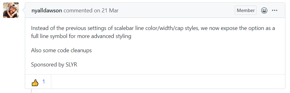
Allow customisation of division and subdivision symbols as distinct from scalebar tick horizontal symbol
- Author: nyalldawson
- Milestone: 3.14.0
- PR: 36222
- Merged: 2020-05-07T00:56:51Z
- tags: Print Layouts
- Sponsored by: SLYR

allow creating geometryless DBF tables from the New Shapefile dialog (fix #15654)

Vector tile layer - part 8 (writer in Processing)
- Author: wonder-sk
- Milestone: 3.14.0
- PR: 36099
- Merged: 2020-05-08T10:55:T10Z
- tags: Vector tiles
- Donors: https://www.lutraconsulting.co.uk/blog/2020/04/02/vectortiles-donors/

allow to drag’n’drop layer across several QGIS instances
- Author: 3nids
- Milestone: 3.14.0
- PR: 35382
- Merged: 2020-05-06T14:04:T08Z
- tags: -
- Sponsored by: the QGIS Swiss user group

enhance sorting capabilities in attribute table list/form view
- Author: 3nids
- Milestone: 3.14.0
- PR: 36199
- Merged: 2020-05-06T06:45:T08Z
- tags: GUI/UX
- Sponsored by: the QGIS Swiss user group

Expose control over layer legend splitting behavior on a layer-by-layer basis
- Author: nyalldawson
- Milestone: 3.14.0
- PR: 36224
- Merged: 2020-05-06T06:27:33Z
- tags: Print Layouts
- Sponsored by: SLYR
allow editing of links in file widget
- Author: 3nids
- Milestone: 3.14.0
- PR: 36190
- Merged: 2020-05-06T04:46:55Z
- tags: Forms
- Sponsored by: the QGIS Swiss user group

Snap on mesh elements
Allow filtering WM(T)S list in source dialog
- Author: 3nids
- Milestone: 3.14.0
- PR: 36166
- Merged: 2020-05-05T05:21:00Z
- tags: GUI/UX
- Sponsored by: the QGIS Swiss user group

Allow overriding the default symbol for a legend node
- Author: nyalldawson
- Milestone: 3.14.0
- PR: 36162
- Merged: 2020-05-05T01:49:07Z
- tags: Print Layouts
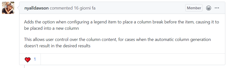
Allow placing manual column breaks in legends
- Author: nyalldawson
- Milestone: 3.14.0
- PR: 36136
- Merged: 2020-05-05T14:22:28Z
- tags: Print Layouts
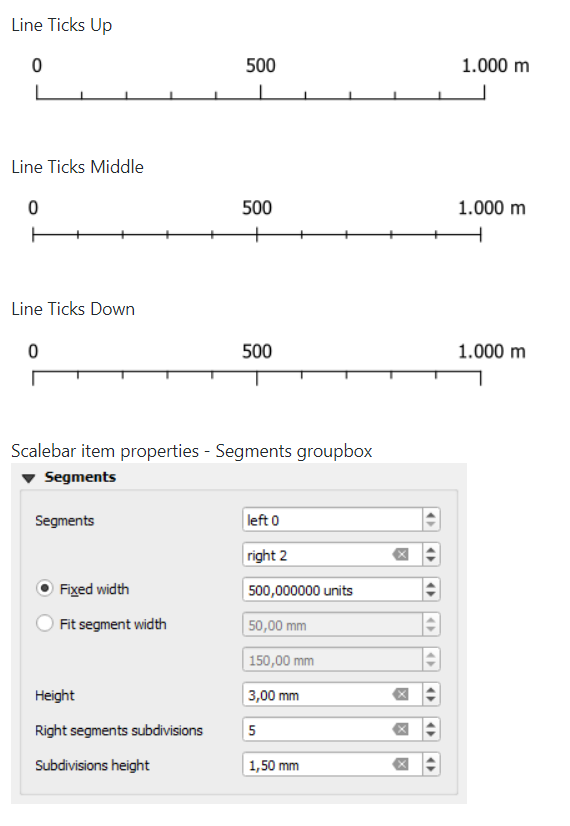
Add subdivisions in ticksscalebar right segments
- Author: agiudiceandrea
- Milestone: 3.14.0
- PR: 36131
- Merged: 2020-05-05T23:12:37Z
- tags: Print Layouts
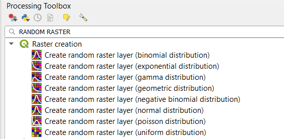
Complete random raster algorithm collection #2
Automatic placement of labels outside polygons
- Author: nyalldawson
- milestone: 3.14.0
- PR: 36106
- Merged: 2020-05-03T19:38:49Z
- tags: Labeling
- Sponsored by: the Swiss QGIS user group

Feature browser for preview in expression builder
- Author: 3nids
- milestone: 3.14.0
- PR: 36089
- Merged: 2020-04-30T15:50:11Z
- tags: GUI/UX
- Sponsored by: the QGIS Swiss User Group!

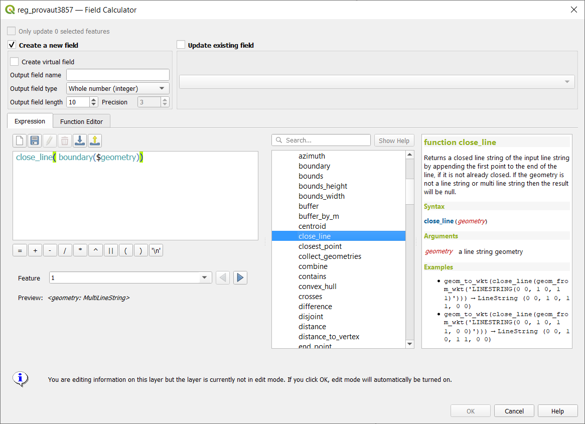
add expression close_line
Allow overriding the legend patch size on a per-item basis
- Author: nyalldawson
- milestone: 3.14.0
- PR: 36013
- Merged: 2020-04-28T01:31:45Z
- tags: Print Layouts
- Sponsored by: SLYR

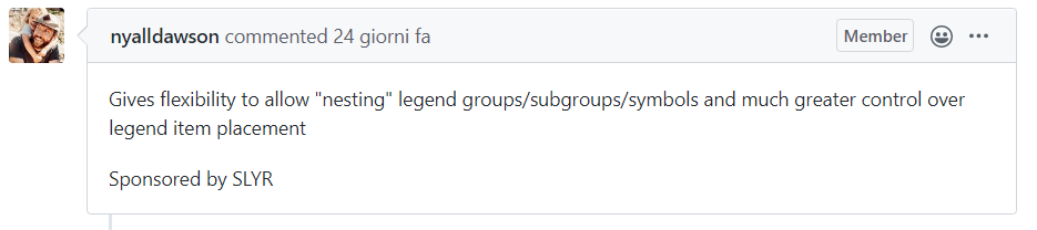
Allow control over the horizontal spacing before legend group/subgroup/symbols
- Author: nyalldawson
- milestone: 3.14.0
- PR: 35974
- Merged: 2020-04-24T18:49:55Z
- tags: Print Layouts
- Sponsored by: SLYR
Support for adding dock widgets as tabs
- Author: gacarrillor
- milestone: 3.14.0
- PR: 35933
- Merged: 2020-05-03T07:34:55Z
- tags: GUI/UX

Expressions for geometry Z and M minimum and maximum
1D mesh width/color varying

Allow renaming of the current map theme

Manage legend patch shapes through style manager
- Author: nyalldawson
- milestone: 3.14.0
- PR: 35909
- Merged: 2020-04-22T02:43:03Z
- tags: Map and Legend

ability to remove custom functions (fix #27513)
add is_multipart expression for geometry
Allow configuring legend patch shapes by double-clicking on legend items
- Author: nyalldawson
- milestone: 3.14.0
- PR: 35863
- Merged: 2020-04-21T00:40:51Z
- tags: Print Layouts
- Sponsored by: SLYR

ascii expression
Support pasting pictures directly into layouts
- Author: nyalldawson
- milestone: 3.14.0
- PR: 35821
- Merged: 2020-04-17T03:48:07Z
- tags: Print Layouts
Add vector tiles to Datasource manager dialog and Layers menu
New modeler algorithm for creating conditional branches
- Author: nyalldawson
- milestone: 3.14.0
- PR: 35808
- Merged: 2020-04-16T06:02:54Z
- tags: Processing
- Sponsored by: Andreas Neumann
import/export for ArcGIS Map and FeatureServer connections
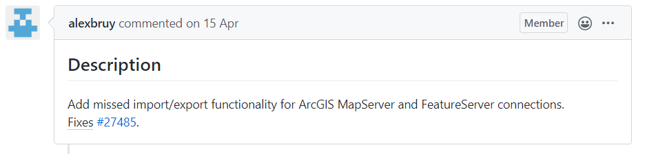
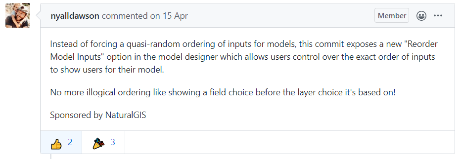
Allow reordering model inputs
- Author: nyalldawson
- milestone: 3.14.0
- PR: 35778
- Merged: 2020-04-15T20:03:49Z
- tags: Processing
- Sponsored by: NaturalGIS
Add XYZ tiles to Datasource manager dialog and Layers menu
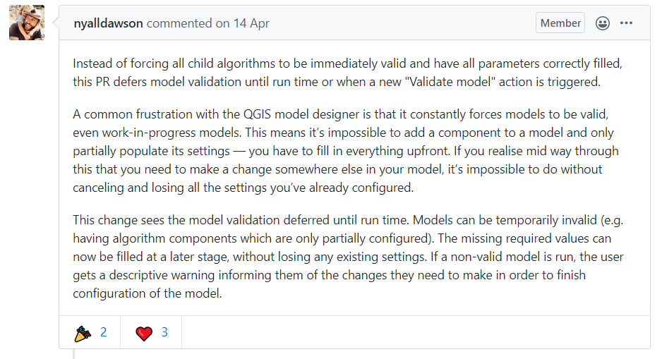
Defer model validation
- Author: nyalldawson
- milestone: 3.14.0
- PR: 35760
- Merged: 2020-04-14T10:27:22Z
- tags: Processing
Vector tile layer - part 5 (identify tool)
- Author: wonder-sk
- milestone: 3.14.0
- PR: 35748
- Merged: 2020-04-15T11:38:21Z
- tags: Vector tiles
- Donors: https://www.lutraconsulting.co.uk/blog/2020/04/02/vectortiles-donors/

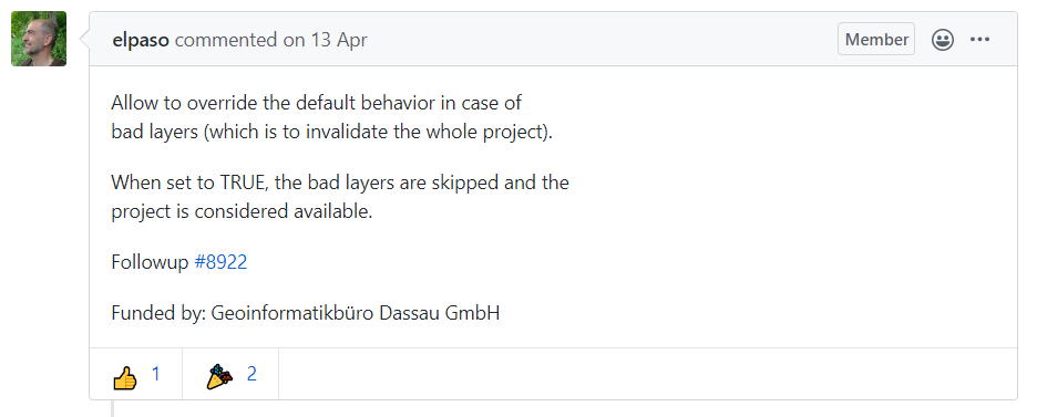
Server add QGIS_SERVER_IGNORE_BAD_LAYERS config option
- Author: elpaso
- milestone: 3.14.0
- PR: 35738
- Merged: 2020-04-14T05:57:10Z
- tags: Server
- Funded by: Geoinformatikbüro Dassau GmbH
Update to MDAL 0.5.91 Multi meshes in one file

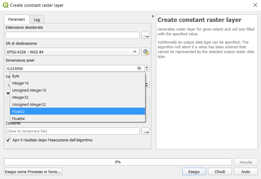
Add support for different raster data types in Create constant raster layer algorithm
add native Round raster algorithm


Add avoid intersection/overlap mode
- Author: nirvn
- milestone: 3.14.0
- PR: 35689
- Merged: 2020-04-10T06:42:08Z
- tags: Digitizing
- Sponsored by: QField

Forms: expression controlled aliases (labels)
- Author: elpaso
- milestone: 3.14.0
- PR: 35688
- Merged: 2020-04-15T13:09:15Z
- tags: Forms
- Funded by: ARPA Piemonte

Vector tile layer - part 4 (labeling)
- Author: wonder-sk
- milestone: 3.14.0
- PR: 35657
- Merged: 2020-04-14T22:33:30Z
- tags: Vector tiles
- Donors: https://www.lutraconsulting.co.uk/blog/2020/04/02/vectortiles-donors/

Allow copying/cut/paste of model components
- Author: nyalldawson
- milestone: 3.14.0
- PR: 35644
- Merged: 2020-04-14T04:36:03Z
- tags: Processing

Allow appending processing results to existing layers
- Author: nyalldawson
- milestone: 3.14.0
- PR: 35641
- Merged: 2020-04-07T07:05:45Z
- tags: Processing

Allow plugins to register custom Project Open handlers
- Author: nyalldawson
- milestone: 3.14.0
- PR: 35606
- Merged: 2020-04-06T23:18:50Z
- tags: API

Allow marker items to sync rotation with maps
- Author: nyalldawson
- milestone: 3.14.0
- PR: 35591
- Merged: 2020-04-06T04:04:21Z
- tags: Print Layouts
- Sponsored by: SLYR

New item type for marker symbols
- Author: nyalldawson
- milestone: 3.14.0
- PR: 35576
- Merged: 2020-04-05T04:23:23Z
- tags: Print Layouts

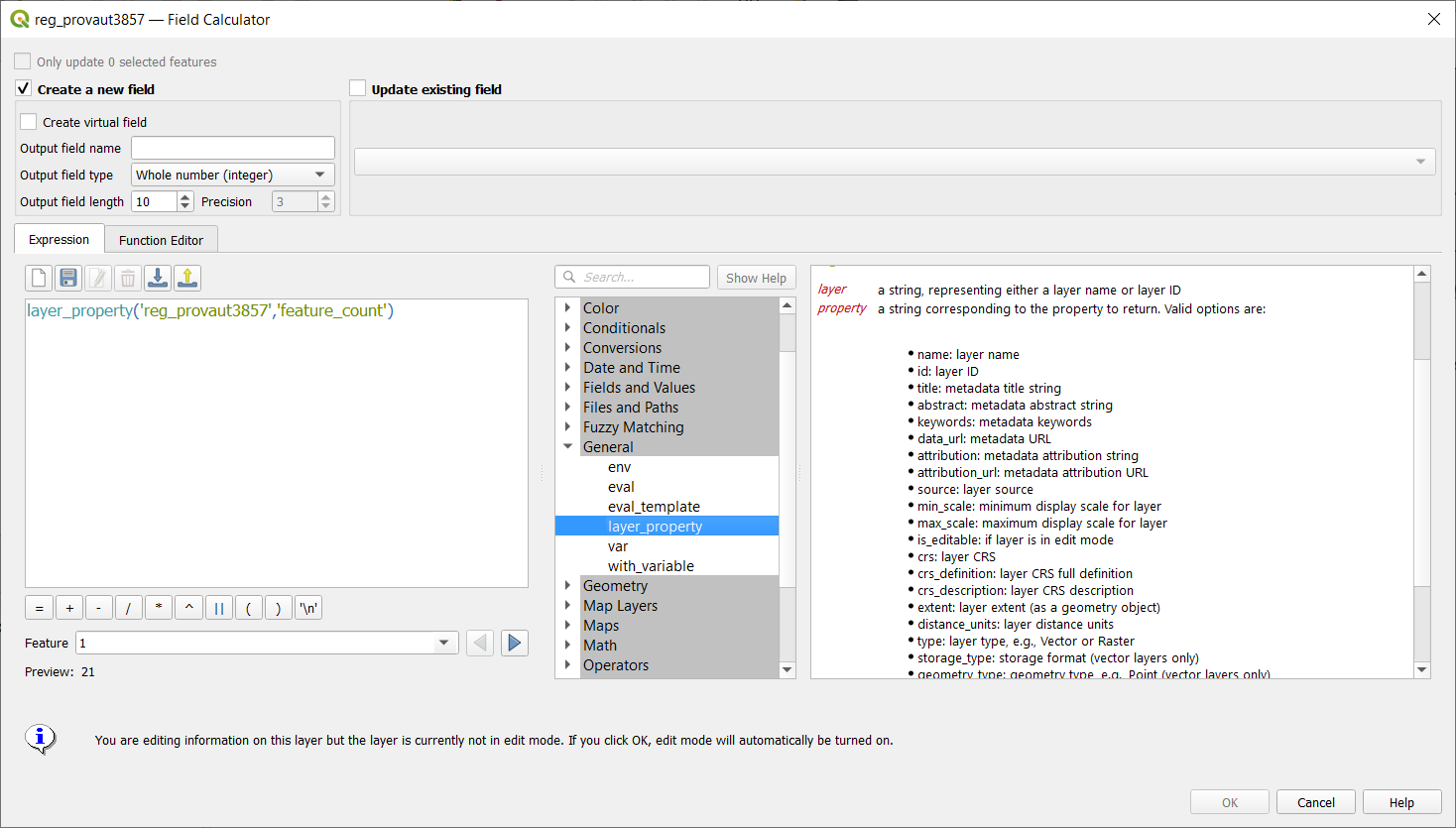
Expression builder add layer_property
- Author: jmonticolo
- milestone: 3.14.0
- PR: 35559
- Merged: 2020-04-06T23:20:39Z
- tags: Expressions
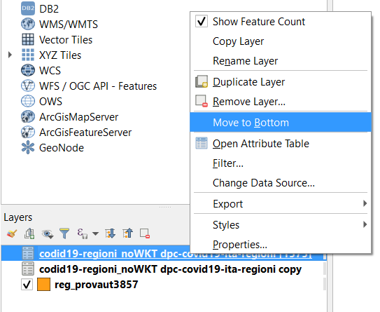
Added move to bottom in layertreeview context menu
Show a menu next to scale widget buttons, to allow setting the widget directly to a scale from a print layout map
- Author: nyalldawson
- milestone: 3.14.0
- PR: 35518
- Merged: 2020-04-02T23:06:10Z
- tags: GUI/UX

Postgres raster temporal API support
- Author: elpaso
- milestone: 3.14.0
- PR: 35511
- Merged: 2020-04-06T19:54:23Z
- tags: Data Provider;Raster
- Funded by: ARPA Piemonte

Allow creation of group boxes in models
- Author: nyalldawson
- milestone: 3.14.0
- PR: 35494
- Merged: 2020-04-01T08:20:10Z
- tags: Processing

Spatialite provider transactions
- Author: elpaso
- milestone: 3.14.0
- PR: 35488
- Merged: 2020-04-01T09:15:15Z
- tags: Data Provider
- Funded by: ARPA Piemonte

Port output parameter wrappers to new API
- Author: nyalldawson
- milestone: 3.14.0
- PR: 35484
- Merged: 2020-04-01T16:29:55Z
- tags: Processing

Add import content from clipboard for fixed table items

Processing: show input and output values for children after running model through designer
- Author: nyalldawson
- milestone: 3.14.0
- PR: 35474
- Merged: 2020-03-31T09:35:52Z
- tags: Processing

Add Save Log to File algorithm for models
- Author: nyalldawson
- milestone: 3.14.0
- PR: 35473
- Merged: 2020-03-31T09:35:30Z
- tags: Processing
plug mesh layer to QGIS temporal framework

Network logger - more functionality
- Author: nyalldawson
- milestone: 3.14.0
- PR: 35454
- Merged: 2020-03-31T02:53:44Z
- tags: -
Port last remaining input parameters to new API
- Author: nyalldawson
- milestone: 3.14.0
- PR: 35452
- Merged: 2020-03-30T15:06:49Z
- tags: Processing
Raster Layer Contour Renderer

Add percentage size unit for Raster Image Marker and Raster fill layers symbology.


Port Feature Source, Raster, Vector and Mesh Layer parameters to new API
- Author: nyalldawson
- milestone: 3.14.0
- PR: 35419
- Merged: 2020-03-28T19:56:24Z
- tags: Processing

Server project settings, add ‘expanded’ attribute
Inbuilt network logging tool
- Author: nyalldawson
- milestone: 3.14.0
- PR: 35396
- Merged: 2020-03-30T06:54:23Z
- tags: -

Allowing saving outputs direct to more database formats (and other nice stuff)
- Author: nyalldawson
- milestone: 3.14.0
- PR: 35364
- Merged: 2020-03-26T15:30:28Z
- tags: Processing

Vector tile layer - part 1
- Author: wonder-sk
- milestone: 3.14.0
- PR: 35341
- Merged: 2020-04-02T14:06:31Z
- tags: Vector tiles
- Donors: https://www.lutraconsulting.co.uk/blog/2020/04/02/vectortiles-donors/

Allow running algorithms directly on database (and other non-disk) sources without loading into projects first
- Author: nyalldawson
- milestone: 3.14.0
- PR: 35324
- Merged: 2020-03-26T01:55:47Z
- tags: Processing

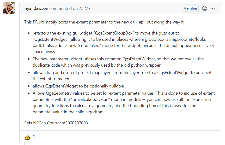
Port processing extent parameter to new api, many other improvements
- Author: nyalldawson
- milestone: 3.14.0
- PR: 35321
- Merged: 2020-03-25T09:25:42Z
- tags: Processing
Interface and API for unified development/debugging tools
- Author: nyalldawson
- milestone: 3.14.0
- PR: 35319
- Merged: 2020-03-25T10:03:19Z
- tags: API

Expose per-feature-source advanced options for processing inputs
- Author: nyalldawson
- milestone: 3.14.0
- PR: 35292
- Merged: 2020-03-24T23:42:18Z
- tags: Processing

Resampling from vertex values to face values

Enable snapping to grid for models in designer
- Author: nyalldawson
- milestone: 3.14.0
- PR: 35251
- Merged: 2020-03-23T09:25:34Z
- tags: Processing
Add numeric formatter fraction style
- Author: nyalldawson
- milestone: 3.14.0
- PR: 35244
- Merged: 2020-03-23T04:24:38Z
- tags: Print Layouts
- Sponsored by: SLYR

Add stepped line and hollow scalebar styles
- Author: nyalldawson
- milestone: 3.14.0
- PR: 35238
- Merged: 2020-03-22T17:08:51Z
- tags: Print Layouts
- Sponsored by: SLYR


Allow scalebar line style to be set using standard QGIS line symbols
- Author: nyalldawson
- milestone: 3.14.0
- PR: 35225
- Merged: 2020-03-22T06:41:32Z
- tags: Print Layouts
- Sponsored by: SLYR
Add data-defined property to font family/style for font markers

coloring mesh vector dataset with color ramp shader

add maptip, expression display and eval_template expressions
Add @layers, @layer_ids project scope variables
- Author: nyalldawson
- milestone: 3.14.0
- PR: 35208
- Merged: 2020-03-20T02:56:23Z
- tags: Expressions
- Sponsored by: SLYR
Add a font style setting for font markers

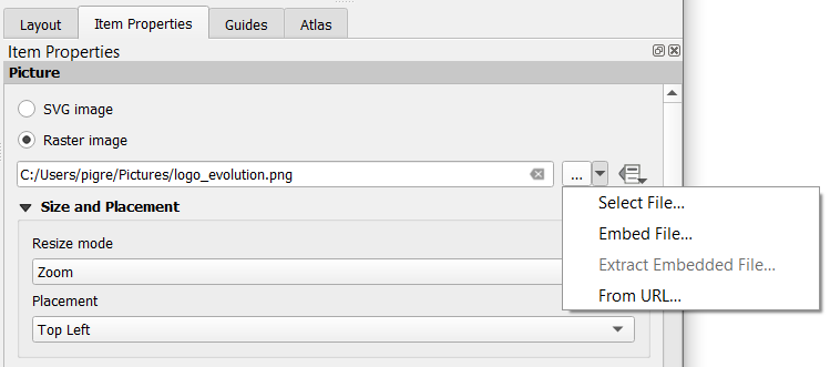
Rework picture item UI and behavior
- Author: nyalldawson
- milestone: 3.14.0
- PR: 35160
- Merged: 2020-03-19T03:18:49Z
- tags: Print Layouts
- Sponsored by: SLYR
Add filter by geometry type and filter by layer type algorithms to processing
- Author: nyalldawson
- milestone: 3.14.0
- PR: 35130
- Merged: 2020-03-17T16:52:38Z
- tags: Processing
the two new algorithms are not present in the updated master today (OSGeo4W64)
Add ability to edit, import and export user expressions
- Author: suricactus
- milestone: 3.14.0
- PR: 34997
- Merged: 2020-03-17T10:31:38Z
- tags: GUI/UX
Make Add Group button act as Group Selected if selected layers >= 2

-
Add toolbutton to Deselect Features from the Current Active layer
- Author: suricactus
- milestone: 3.14.0
- PR: 35085
- Merged: 2020-03-18T03:26:49Z
- tags: GUI/UX

Optionally, also remove EMPTY geometries in RemoveNullGeometries algorithm
- Author: gacarrillor
- milestone: 3.14.0
- PR: 35084
- Merged: 2020-03-15T07:37:53Z
- tags: Processing

Data type support for QgsProcessingParameterMapLayer
Add processing parameter types for database schema and table name
- Author: nyalldawson
- milestone: 3.14.0
- PR: 35056
- Merged: 2020-03-14T06:57:16Z
- tags: Processing
Add description to value relation widget

Add multi-selection handling to model designer, interactive resizing
- Author: nyalldawson
- milestone: 3.14.0
- PR: 34987
- Merged: 2020-03-12T03:14:34Z
- tags: Processing

Save style for mesh layer

New database table name widget

Add dedicated parameter type for database connections
- Author: nyalldawson
- milestone: 3.14.0
- PR: 34955
- Merged: 2020-03-10T09:10:54Z
- tags: Processing
arrows for 3D mesh layer dataset rendering

Add undo/redo support to model designer
- Author: nyalldawson
- milestone: 3.14.0
- PR: 34938
- Merged: 2020-03-10T22:39:55Z
- tags: Processing

Add control over anchor point for callout on label
- Author: nyalldawson
- milestone: 3.14.0
- PR: 34936
- Merged: 2020-03-09T05:29:52Z
- tags: Labeling

PG expose foreign tables
Add expression variables for current map temporal range
- Author: nyalldawson
- milestone: 3.14.0
- PR: 34898
- Merged: 2020-03-08T21:29:46Z
- tags: Expressions
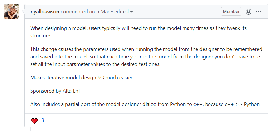
Remember parameter values between model designer runs
- Author: nyalldawson
- milestone: 3.14.0
- PR: 34895
- Merged: 2020-03-06T08:22:51Z
- tags: Processing
- Sponsored by: Alta Ehf
Plugin manager allow to install stable or experimental
- Author: olivierdalang
- milestone: 3.14.0
- PR: 34876
- Merged: 2020-03-15T19:31:18Z
- tags: Plugins

PG raster expose set filter to app
- Author: elpaso
- milestone: 3.14.0
- PR: 34871
- Merged: 2020-03-05T14:34:33Z
- tags: Data Provider;Raster
- Funded by: ARPA Piemonte

Comments in Processing Models
- Author: nyalldawson
- milestone: 3.14.0
- PR: 34856
- Merged: 2020-03-05T17:49:17Z
- tags: Processing
- Funded by: Fisel + König

Mesh 1D Renderer
- Author: PeterPetrik
- milestone: 3.14.0
- PR: 34848
- Merged: 2020-03-09T04:59:52Z
- tags: Mesh

Get current parent form values in child forms
- Author: elpaso
- milestone: 3.14.0
- PR: 34827
- Merged: 2020-03-05T09:51:44Z
- tags: Forms
- Funded by: ARPA Piemonte

Relation wdgt: add checkbox to hide save child edits button

Relation widget force suppress popup

New standalone console tool for running processing algorithms
- Author: nyalldawson
- milestone: 3.14.0
- PR: 34617
- Merged: 2020-04-15T08:20:28Z
- tags: Processing
- Sponsored by: the Swedish User Group
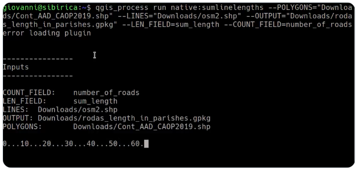
https://twitter.com/i/status/1250506567528722433
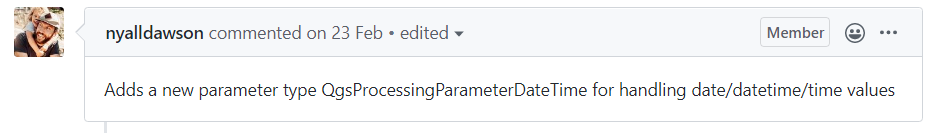
New parameter type for Merged (or date, or time) values
- Author: nyalldawson
- milestone: 3.14.0
- PR: 34610
- Merged: 2020-02-24T07:23:42Z
- tags: Processing
QGIS Project temporal settings

Make CRS controlable by a variable

Mesh simplification

WMS-T layers temporal constrains support

Temporal API

New snapping modes: Centroid and middle of a segment (midpoint)
- Author: lbartoletti
- milestone: 3.14.0
- PR: 33622
- Merged: 2020-03-02T08:02:36Z
- tags: Digitizing
- Sponsored by: Qwat group / Ville de Lausanne ( @ponceta @dsavary ) / Oslandia and some spare time

Show ‘template layer’ constraints info in the Refactor fields algorithm’s UI
- Author: gacarrillor
- milestone: 3.14.0
- PR: 31387
- Merged: 2020-03-18T06:10:07Z
- tags: Processing

Statistics
Authors
Tags
| tags | count | percent | histogram |
|---|---|---|---|
| Processing | 29 | 21.01 | ****************** |
| Print Layouts | 18 | 13.04 | *********** |
| - | 12 | 8.70 | ******** |
| GUI/UX | 12 | 8.70 | ******** |
| Expressions | 11 | 7.97 | ****** |
| Mesh | 11 | 7.97 | ********* |
| Temporal | 10 | 7.25 | ********* |
| Forms | 6 | 4.35 | **** |
| Symbology | 6 | 4.35 | **** |
| Data Provider | 5 | 3.62 | **** |
| API | 4 | 2.90 | ** |
| Vector tiles | 4 | 2.90 | ** |
| Labeling | 2 | 1.45 | *** |
| Server | 2 | 1.45 | *** |
| Digitizing | 2 | 1.45 | *** |
| Raster | 2 | 1.45 | *** |
| Vectors | 1 | 0.72 | * |
| Documentation | 1 | 0.72 | * |
| Map and Legend | 1 | 0.72 | * |
| QGIS Browser | 1 | 0.72 | * |
| Plugins | 1 | 0.72 | * |
Sponsors
| Sponsored by | count |
|---|---|
| SLYR | 11 |
| the QGIS Swiss user group | 6 |
| ARPA Piemonte | 5 |
| https://www.lutraconsulting.co.uk/blog/2020/04/02/vectortiles-donors/ | 4 |
| Geoinformatikbüro Dassau GmbH | 1 |
| Fisel + König | 1 |
| Andreas Neumann | 1 |
| NaturalGIS | 1 |
| QField | 1 |
| Alta Ehf | 1 |
| the Swedish User Group | 1 |
| Qwat group / Ville de Lausanne ( @ponceta @dsavary ) / Oslandia and some spare time | 1 |
| geoProRegio AG (www.geoproregio.ch) | 1 |
Useful references:
- VisiData : https://www.visidata.org/
- Miller : https://github.com/johnkerl/miller
- xq : https://github.com/kislyuk/yq
- Scrape : https://github.com/aborruso/scrape-cli
- curl : https://curl.haxx.se/
- Blog Pigrecoinfinito: https://pigrecoinfinito.com/